|
GOING
BACK TO PLACES THAT I
HAVE NEVER BEEN
Being
a Field Guide to Hanoi and Dien Bien Phu for
Historians,
Wargamers and the More Discerning Type of Tourist
by
Peter
Hunt
Part
Three: West of the River and
Beyond
The
Bailey bridge across the
Nam
Yum
River
is still in daily use.
So in this respect the battle is at least doing some good for the
people of
Dien Bien Phu
even 50 years later.
The Bridge itself was a later addition to the infrastructure of the
French position. The original
crossing over the river was by a wooden bridge further south, of which I
could find no trace. North of
the bridge the river meanders to the new road bridge.
On the eastern side of the river at this point was the “dead arm”
of the Nam Yum where a meander had been cut off.
This is now just an area of boggy ground.
From the Bailey bridge or the road bridge you can get good views of
the “cliffs of the Nam Yum” where the “rats” ~ the hundreds, perhaps
thousands of internal deserters of the camp, lived in dug outs and caves.
The “cliffs” are no such thing, they are really just the steep
banks of the river cut by its meanders into the soft alluvial soil about
three to six metres high.
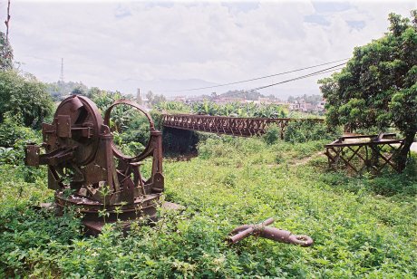
The Bailey
Bridge and Quad.50
On
the western side of the bridge are two things to note.
On the southern side is a marker commemorating the first Viet Minh
unit to get across. Translated
it says:-
“At
2 p.m.
on
7th May 1954
Company 360, Division 312 attacked and took
Muong
Thanh
Bridge
, striking at the heart of the enemy and inflicting
defeat on the high command of the
Dien Bien Phu
group of fortresses.”
The
jubilation that those men must have felt after the months of siege can only
be imagined. On the north side
is one of the reasons that the Viet Minh took so long to get there: the
remnants of a quad .50 calibre machine gun. There were four of these weapons
at Dien Bien Phu, two placed further north of the bridge on
“Sparrowhawk” and two placed further south on “Juno”, so how this
one got to the end of the bridge is anyone’s guess.
It was probably moved after the battle but it might have been moved
in the last few days of combat. The
quad 50s kept firing up to the last day.
There was no shortage of ammunition, even for their prodigious
appetites, and, unlike the tube artillery they had no recoil hydraulics
vulnerable to near misses from Viet Minh shellfire.
 |
|
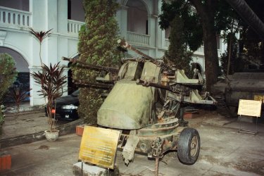
Quad.50 at
the Hanoi Army Museum |
If
you want to scratch-build a quad 50 Raventhorpe make the upper body as a
conversion for half-tracks. The
lower body is easy to knock up with a couple of aircraft wheels.
Cut up electrical wire provides you with the heaps of brass cartridge
cases strewn around that were the hallmarks of these weapons in action.
Claudine
At
the western end of bridge there is now a row of soup and coffee shacks.
At the crossroads beyond them is where the hospital was.
By the end of the battle this had been extended all the way to De
Castries bunker. To understand
the horrors and heroism that went on beneath your feet, (for the hospital
was mostly underground,) Major Grauwin’s “Doctor at
Dien Bien Phu
” is a must read. Nothing
now remains of the hospital except that old photograph in the
Air
Force
Museum
in
Hanoi
.
At
the road junction a “Bison” Chaffee tank and pile of aircraft wreckage
stand mute testimony to the French defeat.
Turn left and you come to that defeats most memorable visible symbol
~ De Castries’ Command bunker, immortalised forever by the image of that
Viet Minh soldier waving the gold star and red flag of the new
Vietnam
above it.
A
small entrance fee gets you into the bunker, which has been preserved with
concrete sand bags, but the layout, the corrugated steel roof and the
pierced steel plates inside, that were originally used on the French
airstrip, are authentic. The
place is cool even on the hottest days but the gloom and the knowledge of
what went on down there leaves you in little mood to tarry.
There has been no attempt to turn it into a museum of the battle and
the fact that the rooms are mostly empty just adds to the sense of history ~
with nothing there it is easier to imagine the hubbub of the radio traffic,
the desperate messages going in and out; and the anguished decisions being
made. It really is an eerie
place.
|
|
|
De Castries' Bunker |
Walk
back to the road and continue south. Another
“Bison” looks out over the flood plain of the Nam Yum towards Elaine on
the other side. The original
wooden bridge would have been about here but the river and cultivation have
changed things since 1954. This
is a good lookout as it is difficult to get to the river at other points on
this side. You can take in the
length of the central position from the Bailey Bridge to the north, to where
“Juno” would have been to the south.
 |
|
The French
Memorial |
Keep
walking south and you come to the French Memorial.
This is an odd little place as it is a “free enterprise” effort
created by an “Ancien” of the Foreign Legion, not an official memorial
by the French or Vietnamese governments.
Still it’s a touching place and all the more so as a “grass
roots” memorial from and to the guys who fought at Dien Bien Phu.
When I visited it was a little bit scruffy and needed some paintwork.
I hope that it is spruced up for the 50th Anniversary.
It deserves it.
Back
at De Castries' bunker you are in the centre of the Claudine positions and
the gun lines are marked by rusting artillery pieces.
Across the road to the north of the bunker there is a 105 mm howitzer
and to the west of the bunker are a 155 mm howitzer and two more 105s.
Further west the Claudine and Francois defensive positions have
disappeared under housing and agriculture so there is not much to see here.
From the layout of the housing you can work out the original path of
the “Piste Pavie” track which was the main north-south route at the time
of the battle but which has now been replaced by the main highway on the
eastern side of the river and the smaller road on the western side.
If you follow this north you will come to the valley’s main
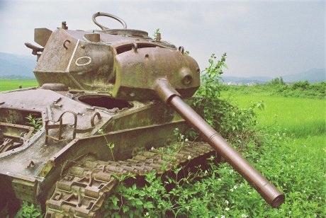
east-west road and yet another Bison, sitting on its own in a little bog.
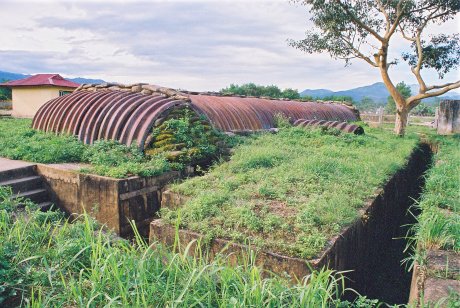
The Huguettes
Using
this tank as a landmark take the sidetrack to the north and you will be
entering the area of the Huguettes positions which were intended to defend
the airstrip. The first landmark
is the steep sided creek that flows roughly east to west into the Nam Yum.
At the time of the battle this was bridged at several locations
including a special bridge between the airstrip and the dispersal area for
the Bearcat fighter bombers and Morane “Criquets” based at
Dien Bien Phu
. On my visit
all I could find was a narrow footbridge through a farm yard.
Since
the airstrip itself has been moved, extended and concreted I wasn’t
expecting to find much to justify sinking up to my calves in the paddy
fields but I was pleasantly surprised. Huguette
2 is marked by a marker and the last of the Bisons.
The path of the “Piste Pavie” is quite clear leading off to the
site of “Ann Marie”, later renamed Huguette 6 and 7.
Likewise the path of the drainage ditch that used to run on the east
side of the airstrip is still clear, although today it is on the west of the
new strip.
 |
|
The
Disconsolate Bison |
The
Bison at Huguette 2 seems the most disconsolate of all the tanks at
Dien Bien Phu
. Its gun
dips sadly over its shattered body. Although
there is nothing left of the trench works the sharp contrast between the
situation on the Huguettes and the “Five Hills” east of the river is
brought home to you. At least on
the hills there was dead ground to take cover in.
Here by the airstrip everything is completely flat.
The soldiers on both sides could only survive because of their
trenches and both sides paid a high cost in blood to extend their own
trenches or take out the enemy’s. One
of the best Viet Minh accounts of the battle is by battalion commander
Nguyen Quoc Tri in “Operation on the Stomach” (Vietnamese Studies No. 3,
March 1965.) It was Nguyen’s
battalion that was charged with digging an approach trench right up to the
airstrip a few hundred meters north of Huguette 2.
The 140 meter trench cost him two thirds of his unit in three nights
and two days of fighting in early April 1954.
I
wasn’t able to walk up the Piste Pavie to the Anne Marie positions because
I was shooed away from the runway by guards as the afternoon plane was
arriving. My advice then is to
visit the Huguettes and Anne Marie in the morning.
Unless you are visiting in dry season a good pair of boots is
essential for these positions which consist mostly of paddy.
The berms between the fields are narrow and the mud is glutinous.
I went in to my ankles of my jungle boots several times, shoes or
trainers would have probably been sucked off.
The walk to Anne Marie would be the longest bit of exploration that
you can conveniently do on foot. To
visit the other positions, Giap’s HQ, Beatrice, Gabrielle and Isabelle,
you need some kind of transport, either a car or motorbike, both of which
you can hire for a day and take in the lot.
Giap’s HQ
Although
it is only 14 km from the centre of
Dien Bien Phu
as the crow flies, the journey to Giap’s HQ in the
mountains to the east takes well over an hour.
But the time is well worth it. Both
the journey and the arrival are an education.
The first half of the route is via Highway 279, the old RC 41 which
follows the river valley of the Nam Yum as it carves its way through the
mountains. As the road clings to
the side of several gorges you get amazing views and an introduction to the
ethnic and agricultural background to the area.
The valley bottoms and lower sides of the valleys are populated and
farmed by the Black Tai whilst the tops of the mountains above you are the
home of the Hmong. The Hmong
fields seem to cling to the very precipices in an almost perpendicular,
gravity defying, way. Leaving
the main road at Na Nhan you head south for the Pa Khoang Lake which
wasn’t there at the time of the battle ~ it is the result of a
hydro-electric project. Just
before you get to the
Lake
you turn east again on a road not marked on the
1:250,000 series
Dien Bien Phu
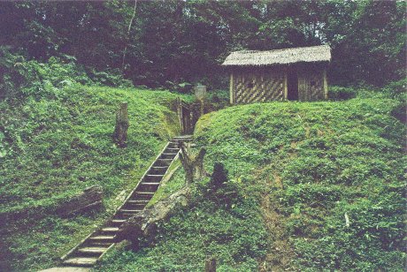
map and travel through Tai villages to Muong Phang.
Here you leave the car and take a 25 minute walk on a well maintained
path through the forested hills to the great man’s HQ.
The
walk through the woods and over little brooks brings you to a fork in the
path and a signboard telling you that you have arrived.
Take the left fork and you will come to Giap’s hut and the entrance
to the underground bunker system. Take
the right fork and you will come to the hut of Giap’s chief of staff,
Hoang Van Thai and another entrance to the tunnel system.
Just before you get to Hoang’s hut the large briefing hut has been
recreated. This is the building
that usually features in the photographs of Giap planning his battle.
Beyond it is an open space where the Headquarters guard post used to
stand.
Giap
gives a nice description of how his CP was located and operated in
“Reminiscing about
Dien Bien Phu
(Vietnamese Studies No. 3, March 1965.)
He calls his hut a “shed” which is pretty apt, as it really is no
bigger than a garden tool shed, and waxes lyrical about the location ~ for
which I don’t blame him because it really is an Arcadian setting:-
“Situated
on the side of very beautiful hill …
covered
with tall, slender, chestnut trees …
The
huts roofed with tiger grass were scattered along a small stream.”
 |
|
Giap's Shed |
Reading
between the lines of his reminisces also tells you a
thing or two. For instance the
construction of the tunnel complex was not begun until late March.
Presumably after the losses taken in capturing Beatrice and Gabrielle
had convinced the Viet Minh that the battle would take much longer than they
had previously thought. Likewise
if April was bad for the French it was desperate for the Viet Minh too.
Their morale was cracking because of the heavy losses and their
supply was a nightmare. Giap
admits to feeling the strain and some considerate staff officer whistled up
an Army Folk Dance Ensemble to cheer him up.
After banging off the usual patriotic, morale raising tub thumpers
the band started singing traditional country folk songs that seem to have
got to Giap:
“Never
before had I felt the beauty of music as I did then during those tense
moments fraught with a great sense of urgency, close to the battlefield.”
Most
of all Giap stresses how
Dien Bien Phu
was a battle of supply ~ the chart next to his desk
recorded supply deliveries, not friendly and enemy casualties.
I
really enjoyed visiting Giap’s HQ, the journey, the location and the
context were all thought inspiring and very different to the rest of
Dien Bien Phu
. For you
dear reader though, a few words of advice: TAKE A TORCH! I didn’t,
(although I had a perfectly good one back at the hotel,) and thus although
the 300 meters of bunkers through the hill between the two entrances seem
quite open I couldn’t explore them in the pitch darkness.
I hope that you will have more luck and will not have to retrace your
route through the forest saying “Doh!” at every step like I did!
Beatrice
You
can drive to Beatrice, or Him Lam as the Vietnamese call it, on the way to
or from Giap’s HQ or even walk there from the Muong Tranh Hotel.
Head east along Route 279 and stay on the same side of the road as
the hotel. About 300 meters from
the hotel you come to a garage “SUA CHO AUTO”, take a left here down an
unpaved lane. About 800 m down
the track you come to a walled enclosure marked “NHA MAY CACN DBP’.
There are ponds on your left and the track makes a 90 degree right
hand turn around the enclosure, follow the road and after about 100 m it
makes another 90 degree left hand turn.
On this bend is a white house. Don’t
follow the road but from the bend you will see a path leading off to your
right: follow this, it leads up a wooded hill and when you get to the top
you are at the Beatrice monument. I
did this at the gallop because I was overtaken by a section of PAVN
NCO/officer candidates doing a map reading exercise and I didn’t want them
to think that steely eyed oriental crime fighters were fat and flabby.
Keeping up their pace almost killed me but I was not the last
casualty of
Dien Bien Phu
and finally got to the top without a heart attack.
They politely but firmly decline my offer of a photo.
The bush is about waist to shoulder high on top of Beatrice. I
briefly turned away from the soldiers to photograph the monument and when I
turned back they had totally vanished. This
was rather spooky as they could not have been more than a few metres from me
but I could not see nor hear anyone. Clearly
the PAVN’s tradition of exceptional fieldcraft is well maintained today.
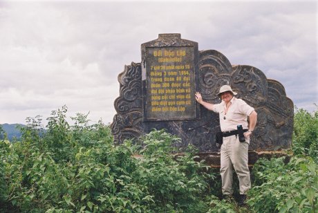
Beatrice
Monument
Beatrice
consisted of three hill positions and I had to admit that I had no idea
which one I was on. It must have
been an important one for the Viets to erect their monument there.
Given the general lie of the ground, and the distance we were from
the road, I suspect I was on B4/B2. With
the state of the bush when I was there it would be difficult to go down and
then up again to B1 or B3, I could not see a path but the PAVN boys had got
through. Again this will
probably be easier in the dry season. The
hills themselves are steep and the Viet Minh assault paid the cost.
It was here that Giot died leading the attack and blocking the
loophole of a French machine gun nest with his own body.
In the end though Beatrice fell because of its isolation.
Although closer to the main position than Gabrielle, Beatrice was
more cut off as the hills and jungle closed in around it whereas the routes
to Gabrielle and Isabelle were over flat open ground.
Beatrice was not essential to the defence of
Dien Bien Phu
, if anything it was a relic of the “offensive” role
of
Dien Bien Phu
as an “air-land base” to launch forays of up to
brigade size into the Tai Highlands. Beatrice
was the jumping off point for these raids.
When Beatrice fell on the first day of the battle the French made
only a very half-hearted attempt to retake it.
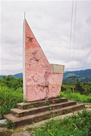
Gabrielle
Gabrielle
or Doc Lap is easier to get to. You
follow the Piste Pavie, (now the paved Route 12) north out of town.
Gabrielle rises like the Torpedo-boat it was first called.
You have to remember that the French were not comparing it to the
sharp lines of a destroyer but to the turtleback shape of a torpedo-boat.
There are large cemeteries to the NW and SE of Gabrielle and the road
between them crosses Route 12 at the foot of Gabrielle.
There are some small shops and the ubiquitous soup cafes here.
Keep on Route 12 which skirts the western flank of Gabrielle and
about 100 meters north of the shops you will see a path leading off up the
slope. It’s a hands on climb
to begin with but the steepest part is by the road. The
path leads straight up to the monument and you get a great view of the whole
valley. When I was there they
appeared to be planting mulberry trees on Gabrielle, possibly to stop
erosion rather than for commercial reasons.
 |
|
Our Hero on
Top of Gabrielle |
From
the top of Gabrielle two things are clear: first what a tough position it
was, secondly how important it was to the defence of
Dien Bien Phu
. Gabrielle
dominates the land around it, and it was the best fortified of the main
positions. It should have been
held and it probably could have been held.
Attacked on the second night of the battle Gabrielle was still
holding out the following morning. A
relief force broke through but garbled messages led the Algerian defenders
to believe that the reinforcements were being sent to evacuate them so they
gave up the hill. If the French
communications had been better the tired but basically sound “Bavowan”
Vietnamese Paratroops would have dug in on top of Gabrielle and the Viet
Minh would have faced the same task again.
Every day that the French held Gabrielle meant one more day of full
air supply as the runway and the drop zones remained clear and the
possibility of air evacuation remained open.
Thus
if the Viet-Minh had not had their “lucky break” on Gabrielle Giap would
have been faced with some hard decisions to make.
Since the losses suffered on Beatrice and Gabrielle anyway obliged
the Viet-Minh to reconsider their tactics and resort to digging and
strangulation over direct assault, if Giap would have had to pay an even
higher price for Gabrielle it is possible that he might have reconsidered
the whole operation, as he did at Na San the year before.
Or, as mentioned in the discussion of Dominique 2, if Gabrielle had
cost another regiment to take the cumulative effect of the meat grinder may
have led to Viet Minh morale decisively cracking after the
Battle
of the Five Hills.
Having
lost Gabrielle the French were in big trouble.
From the top of the hill the valley is laid out before you,
especially the runway and the primary French parachute drop zones used for
reinforcements and supplies. The
flak batteries that the Viet-Minh were able to establish on and around
Gabrielle put a stranglehold on the French Garrison.
Two Roads to the End:
Isabelle
South
from
Dien Bien Phu
proper the valley opens up and it is easy to understand
how the French believed that it was an ideal place to fight a battle of
manoeuvre. The paddies are dead
flat and, although the hills rise to mountains on all sides the feeling is
far less claustrophobic than in the main position.
All-in-all a perfect Devil’s playground for the French armour,
artillery and airpower to smash the infantry of the Viet Minh on.
All the more credit goes to the Viet Minh then for making their
strangulation tactics work on this terrain too.
Fall’s map of Isabelle shows 16 Viet Minh battery positions firing
on the strongpoint and these were not dug into the mountains like those in
the north but somehow concealed on this billiard table.
There are two roads south to Isabelle, the main highway 279 east of
the river and the smaller road to the west of the river.
West
of the river follow the single track road south from the French Memorial.
Once you are clear of the main position this road presumably follows
the route of the old Piste Pavie. It
is very picturesque. You pass
through Thai villages with their thatched long houses and skirt a wide green
sea of rice paddies. Looking out
to the west you can see where Bigeard launched his “flak raid” to
neutralize the Viet Minh AAA on 28th March 1954 and it was from
Isabelle to the south that Lieutenant Preaud’s three “bisons” came
barrelling up across the flat plain to hit the Viet Minh flank and complete
the victory. The raid was a
great fillip to French morale and was the epitome of how they had intended
to fight the whole battle, combining good quality infantry, armour,
artillery and air in a well orchestrated operation.
Sadly for the French Giap gave them little opportunity to repeat such
successes.
East
of the river the main highway provides the quickest route to Isabelle.
Before you get there though you come to the
village
of
Nhoong Nhai
. Here on
25 April 1954
French aircraft bombed a concentration of civilian
refugees, mostly women and children, who had been evacuated from villages
nearer the main areas of conflict. There
is nothing to suggest that this was anything other than one of those ghastly
mistakes that happen in war, not that would be of any consolation to the
victims, or even perhaps to the pilots.
A fair number of French Air Force men were captured at
Dien Bien Phu
and after the battle the Viet Minh made them dig up the
bodies of the women and children and look at them before re-interring them.
It is easy to understand how the Viet Minh felt, and how the French
must have felt.
Today
the site of this tragedy is marked by a simple but striking monument of a
classically dressed woman holding up her dead child in an almost sacrificial
gesture. The monument has not
been well looked after but the slight decay justs adds to the pathos.
It’s a very sad place.
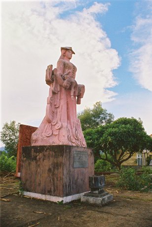 |
|
Monument
to the Bombing Victims |
South
of Noong Nhai lay one of the main reason for Isabelle’s existence ~ the
alternative landing strip for
Dien Bien Phu
. This proved
useless because the main strip was sufficient for all of
Dien Bien Phu
’s needs and the same Viet Minh artillery and flak that
rendered the main strip unusable also neutralised the alternative strip.
The second reason for Isabelle’s existence was that it held one
third of the French artillery which was to provide flanking fire for the
main position. However because
it was so far south of the main position Isabelle’s guns could not reach
the northern positions on Gabrielle and Beatrice so, when the Viet Minh
assaulted these they did not have to worry about neutralizing the artillery
support from Isabelle as well as the main artillery concentration in
Claudine. De Castries was well
aware of this problem and, before the battle started wanted to abandon
Isabelle or replace it with another strongpoint to house the artillery
closer to the main position. But
the false promise of the airstrip kept Isabelle where it was.
The
large marker beside the highway says Isabelle but actually, since you are
still east of the river you are standing at the tip of strongpoint Wieme.
The terrain is perfectly flat and nothing remains of the old
positions which are now covered by a farm and a brick works.
It is a pleasant walk to the river but there is no trace of the
bridge that once connected Wieme with Isabelle proper.
If conditions in the main position of
Dien Bien Phu
were often appalling the conditions on these flat,
flooded, shell shot strongpoints were far worse.
This was “Hell in a very small place.”
Isabelle
was the last part of
Dien Bien Phu
to fall. It
held out because, despite the awful location it was well prepared, with the
best dug outs in the whole valley; its defenders were determined, well they
had nowhere else to go; and although the Viet Minh made several strong
assaults, ultimately they were not prepared to pay the necessary price in
blood to take it. When the main
position was overrun at
5:30 p.m.
on
7th May 1954
Colonel Laland in Isabelle was given permission to
attempt “Operation Albatross” ~ the break out.
This was not the last ditch bayonet charge of Foreign Legion legend
but a two pronged sortie that was quickly intercepted by the Viet Minh.
Although a few made a clean getaway to safety, and more disappeared
in the fire fight or got lost in the jungle clad hills never to be seen
again, most of the garrison fell back to Isabelle in disorder.
At
1:50 a.m.
on
8th May 1954
Laland signalled to
Hanoi
: “Sortie failed. Cannot
communicate with you any more.” The
Battle of Dien Bien Phu had ended.
I
stood beside the
Nam
Yum
River
at Isabelle as the sun went down
alone with my thoughts. It
seemed fitting to end my trip where the battle had ended.
It had been a long trip that had taken me over thirty years.
But finally I had got to go to all of those places that I had been to
so many times before.
go to part two
back to
vietnam
go to part four |